- Full Day
- January to December
- Easy
Highlights of the Cordillera Blanca. The highest tropical mountain range in the world, the Cordillera Blanca is part of the spectacular Andes that form the spine of South America. A mecca for hikers and outdoor enthusiasts, the region boasts over 50 peaks that exceed 15,000 feet, 700 glaciers and 300 lakes.
Culture Chavin de Huantar: Located in the Peruvian Andes, Chavín de Huántar was the strategic capital and religious center of the pre-Inca, Chavín civilization. The project team from the University of California at Berkeley traveled to Chavín to digitally preserve this important site. The project’s goal was to support and supplement archaeological activities and research being conducted by Stanford University with the intent of the new data becoming the foundation for an on-site conservation plan.
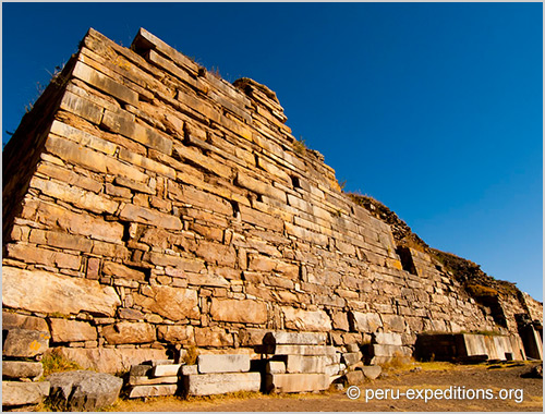
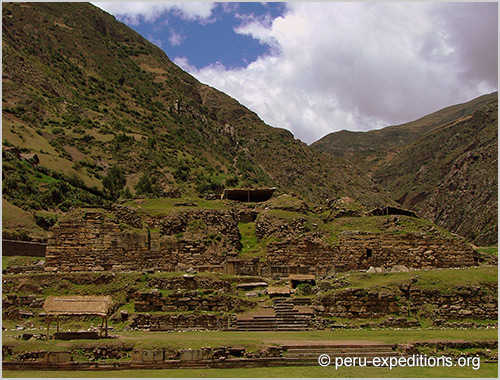
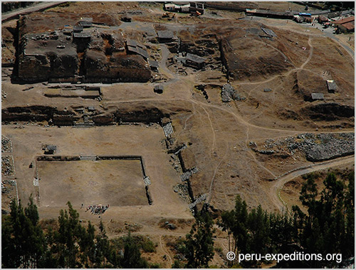
Chavín de Huántar: The archaeological site of Chavín de Huántar sits at an elevation of 3,180m (10,425ft) above sea level in the Peruvian Andes and is located at the confluence of the Mosna and Wacheksa rivers. Chavín once intersected several major trade routes through the Cordillera Blanca mountain range, a strategic location for the capital of the Chavín civilization. The site is located near the Callejón de Huáyla Valley where the village of Chavín de Huántar is located. Chavín is now served by a recently-upgraded, asphalt roadway. Covering 12,000 sq m (129,167 sq ft), the site includes massive temple structures with significant interior and subterranean space, pyramidal platforms, courts, and sunken plaza spaces, most of which are aligned on a common axis. Over time, river floods have eroded much of this stone architecture; its mountainous location has also made it susceptible to destructive landslides (as recent as 1945) and earthquakes (as recent as 1970) over the centuries.
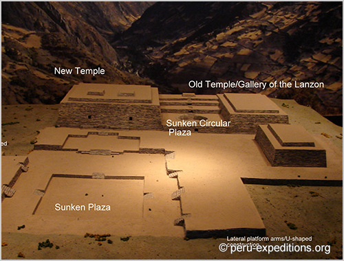
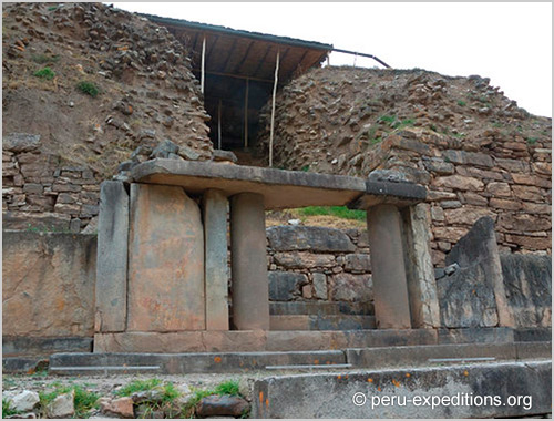
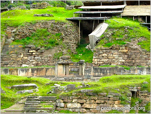
History: Chavín de Huántar was a ceremonial center of the Chavín, a pre-Inca culture. The center was situated at an unparalleled crossroads between the mountains, the jungle, and the sea; the influence of all these environments likely had a strong effect on their culture and iconography, as well as their economy. It was first inhabited around 1500 BCE, during the Initial Period; during this period, the Old Temple was constructed which was a U-shaped temple and platform, encompassing the Circular Plaza. This temple contained several subterranean galleries used for religious rites, storage and possibly living space for groups involved in rituals at the temple. The Lanzón Gallery was housed in the heart of the Old Temple. The site’s most illustrious era was during the Chavín Horizon (800 – 300 BCE). Similar belief systems and rituals were carried out during this new era, but the entire center was enlarged with new constructions. The site of the Old Temple was expanded to include the New Temple, which also had galleries and plaza spaces. The Old Temple is believed to have still functioned after the completion of the New Temple. Social instability and upheaval at Chavín de Huántar occurred between 500 and 300 BCE, the same time that the Chavín civilization began to decline. Sometime after its abandonment, a small village occupied the Circular Plaza and some temples were salvaged for building materials.
Project Narrative: In July 2005, a group of students from the University of California, Berkeley traveled to Chavín de Huántar in Ancash, Peru for an archaeological 3D laser scan documentation project. The project’s goal was to support and supplement the archaeological activities and research being conducted at the site by Stanford University. The intent was the new data would become the base data set for executing a conservation plan for the site. The students implemented HDS, panoramic photography, HR photography, traditional survey, time-lapse photography, and close-range 3D scanning. The subject of the project was all above-ground structures and selected subterranean galleries. The venture was funded jointly by Stanford University and the Kacyra Family Foundation.
Preservation: Chavín’s state of preservation is poor, but gradually improving. In 1998, Peru’s National Institute for Culture (INC) asked for emergency assistance to stabilize and protect the site from the upcoming El Niño weather pattern. During the assistance, which improved drainage and stabilized the galleries, it was noted that the site had never been subject to a specific conservation or preservation effort and the state of conservation of the major structures was extremely poor as a result of climate, structural instability, topography, the materials used in construction, and badly managed tourism. A new access road was recently constructed, but before construction began, Stanford University performed excavations of the location known as “La Banda” in order to secure any archaeological remains and help assure the damage done by the road is minimal. UNESCO has urged Peru to develop a site management plan. The new Chavín Conservation Partnership (CCP) is developing plans to protect the site from excessive tourism due to the construction of a highway to the remote, mountain-top area. The CCP trained a new conservation team in 2004/2005 and the team has begun working on the preparation of 600-800 artifacts for consolidation, conservation, cataloguing, and interpretation. Artifacts are also being prepared from the collections in the site museum and Lima’s National Museum for the new National Museum of Chavín, slated for construction in 2006. Through support and donations a conservation lab and storage facility were purchased in 2004 and the development and enforcement of a site Master Plan is underway.
» Attention / Note about this tour: Every Monday is closed, keep in mind this information
ITINERARY:
Day 1: Huaraz (3100 m) – Privat transport to Recuay – Ticapampa – Catac – Laguna Querococha (4516 m) – Túnel de Cahuish – Valle de Conchucos – Chavín de Huantar (3180 m) – National Museum of Chavin – Return to Huaraz
WHAT’S INCLUDED
Services included in the prices:
- Transport private to start point to hike and viceverse
- Official trekking guide
- Entrance fees to Chavin Temple and Museum
- Pick up at your hotel (at 9:00am)
- First aid kit and oxygen (if necessary)
Not Included:
- International flights to Lima / Peru round trip
- Transfer from the airport for bookings of individual flights with different times of arrival / departure
- Exit tax at the airport in Lima
- Travel accident and health insurance
- Luggage insurance and trip cancellation
- Meals in restaurants in Lima and Huaraz
- Pick up at the airport in Lima to the Hotel
- Transfer from the Hotel to the airport and bus station
- Transport public bus or Domestic flight Airline LC-Peru
- Hotel Casa Andina 2 nights in Lima or other hotel
- Hotel San Sebastián 4 nights in Huaraz or other hotel
- Personal expenses
- Box Lunch (amount depends on you)
- Personal equipment (such as clothes while traveling in the vehicle and hiking. But to be in the sheltered lagoon and hats with earflaps attire is required, hiking shoes, sometimes waterproof/goretex if its rainy season, Sunscreen, Sunglasses, camera, hat or sun hat, sports drinks or water (2 liters approx), etc.)
- Tips
TOUR INFORMATION:
Temporada: January a December
Difficulty: Easy
Dates & Prices:
More information about dates and prices upon request.
Book Now
Photo Gallery